- Screen Colours:
- Normal
- Black & Yellow
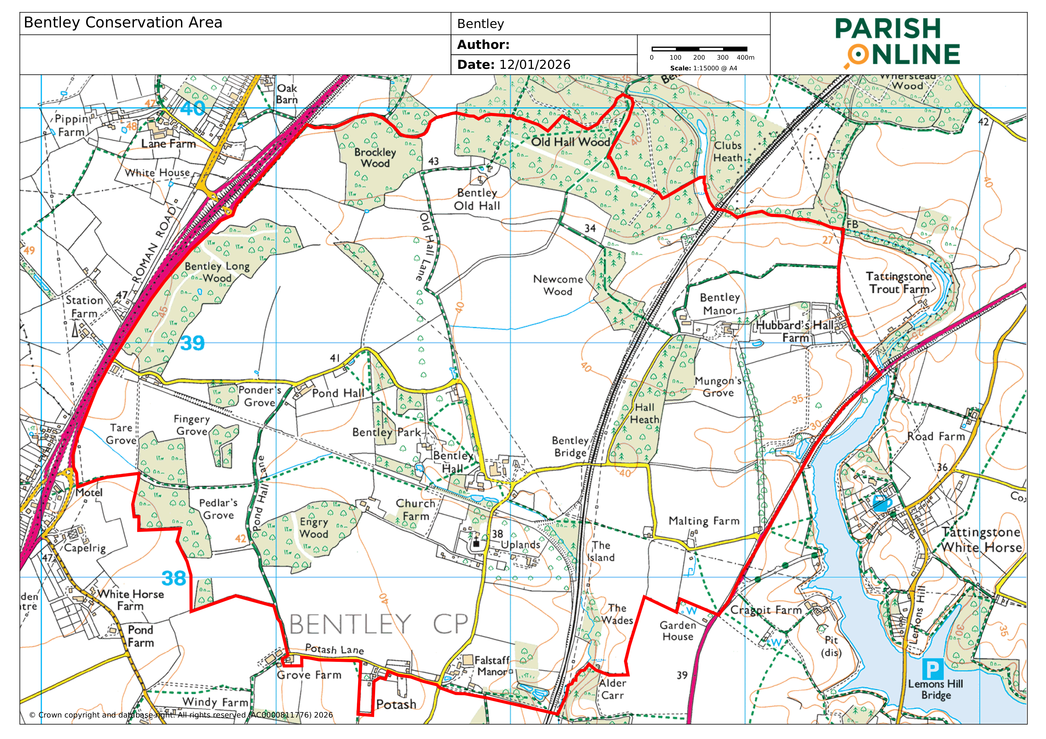
Bentley Conservation Area (outlined in red on the map) was designated by Babergh District Council on 23 April 2025.
The Bentley Conservation Area Appraisal and Management Plan [“CAAMP”] was adopted by Babergh District Council in November 2025 and published on 19th December 2025. This can be viewed on Babergh District Council's website here. [Note this is a large file which may take some time to open.]
The special historic and architectural interest of the Bentley Conservation Area is rooted in its ancient manorial structure and associated connection with the extended Tollemache family who have held land at Bentley from 1200 to the present day. The estate reached its zenith in the mid-16th century when Lionel Tollemache consolidated ownership of the four manors of Bentley, notwithstanding his earlier marriage to the heiress of Helmingham. The manorial structure can still be clearly seen today with 3 of the 4 manor houses (Bentley Hall, Bentley (Church) House and Falstaff Manor) still present within the Conservation Area, all sitting within a mosaic of manorial farmland, ancient woodlands and historic lanes.
Some of the most important buildings are clustered around the Grade II* St Mary’s Church and Grade II* Bentley Hall complex, which includes the Grade I Listed Bentley Hall Barn, reputedly the longest Elizabethan timber framed barn in the country. Bentley Park and Bentley Manor have also both been the centre of Tollemache estates within the Conservation Area.
There are no fewer than 10 named ancient woodlands within the Conservation Area, many of which were actively managed by the Tollemache family’s stewards (including John Constable’s brother Golding) for 800 years, and which still retain their high banked boundaries and distinctive ground flora. Their stable presence within the landscape has helped to preserve its structure over the centuries and discourage agricultural consolidation. Other historic vernacular buildings (largely in their original settings) add special further interest and time-depth to the fabric of the Conservation Area, as does the network of ancient lanes and drovers’ ways, including the Hundred Way on its southern boundary (now Potash Lane), which is thought to be Saxon in origin.
The key features of interest are outlined below:
- the historic core, centred around the grade II* listed church
- open fields and manorial land
- dispersed farmsteads
- ancient woodland
- high quantum of highly graded manor houses and high-status houses, largely set in their historic settings
- modest railway interventions that have resulted in attractive publicly accessible routes, bridges and cottages
- the ancient tracery of footpaths that criss-cross the conservation area